|
|
|
12.221 Field Geophysics |
|
Instructors Tom Herring, Brad Hager |
|
IAP 2005 |
Description
|
Practical
methods of modern geophysics including the Global Positioning System (GPS),
gravity. Field work is conducted in western US and includes intensive 8-day
field exercise. Focus is on measurement techniques and their interpretation.
Introduction to the science of gravity, and the GPS. Measure of crustal
structure, fault motions, tectonic deformations, and the local gravity field.
Students perform high-precision measurements and participate in data
analysis. Emphasis on the principles of geophysical data collection and the
relevance of these data for tectonic faulting, crustal structure, and the
dynamics of the earthquake cycle. This year's
camp will be held North of Blythe California near Vidal. The camp will be located near 34o03'45"
N, 114o32'40" W. |
|
|
|
There is a
follow on communication intensive subject 12.222 that will be offered in the
Spring 2004 semester. This
course satisfies the EAPS CIM requirement. |
|
2004 field
camp web site is 12.221_2004 |
|
|
|
Contacts: |
|
Thomas
Herring, 54-618, 253-5941, 617-980-9526 (cell) tah@mit.edu |
|
Brad Hager 54-622
253-0126, brad@chandler.mit.edu |
|
|
|
Important Dates: Monday December 13, 2004 |
|
$200.00 Fee due Carol
Sprague Room 54-912 253-3381.
Check made payable to MIT.
We need this check to make the flight reservations. |
Detailed Aims of IAP 2005
Course:
|
This year's
camp will be held need Blythe California. We will be looking at two basic topics in the course (a) Measurement
of any motion of GPS marks in the region by comparison of our static GPS
measurements with results from previous GPS surveys and (b) Development of a
sub-surface model for the structure in the region using gravity measurements
collected at field camp with previous gravity measurements. Post-camp analyses will focus on
addressing these two problems and combining the data collected this year with
other data. We will be
interested in the possible effects of ground water use on the surface
positions of GPS monuments. |
Dates:
Course starts: Monday, Jan 3
Field times: Friday, Jan 7 to Friday Jan 14, 2005
Class completion: Thursday Jan 20 to Thursday Jan 27, 2005
|
Logical information: |
|
Items to bring to camp: |
|
* Valid picture ID: Either driver's license or passport. Note: MIT ID or a copy of a passport
is not acceptable form of ID. |
|
*
Tent |
|
*
Sleeping bag (long-range forecast is for mid-30 nights and 50-60 during day). |
|
*
Ground sheet/Sleeping pad |
|
*
Sturdy boots (sufficient to handle rough terrain) |
|
*
Sturdy pair of gloves |
|
*
Sturdy water bottle |
|
*
Hat for sun protection |
|
*
Flashlight (extra batteries) |
|
*
Sun block and moisturizer (air will be dry at 1000m altitude) |
|
*
Field notebook, pens, calculator |
|
*
Laptop computer if you have one you want to bring |
|
*
Some snacks, trial mix, gum (All food will be provided while in camp) |
|
*
Books to read during "off-times" |
|
*
Personnel items and clothing for 7 days in field. Layering of clothing is best for day and night conditions. |
|
*
Swimming gear for stays at hotels |
Flight Itinerary
Depart Logan Airport: United
525/605
6:00 AM, Friday Jan 7, to Palm Springs via Chicago.
Arrive Palm Springs 12:07 PM. Drive directly to field camp.
Meet in parking
lot between Biology and Stata at 4:00 am Friday morning
Return: United 6726/1216
8:29 AM Friday Jan 14, to Boston via Denver.
Arrive Logan airport 6:13 pm
|
Class |
Date |
Topic |
|
1 |
Jan 03 |
Class 10:30-noon 54-320:
Introduction to course material and camp logistics |
|
2 |
Jan 04 |
Class 10:30-noon 54-313:
Basic gravity concepts and applications at field camp. |
|
3 |
Jan 05 |
Class 10:30-noon 54-320:
Basic GPS focusing on general background and aspects needed for field camp |
|
4 |
Jan 06 |
Class 10:30-noon 54-320:
Analysis of data from last year's field camp and planning of measurements for
this year. |
|
5 |
Jan 07 |
Depart for Palm
Springs: Meet in Parking lot between Biology (68) and Stata (32) 4:00 AM |
Meet Here 4:00 AM
Friday
![]()
|
Class Notes and
Assignments |
|
Class Notes |
|
Lec 1 |
Basic introduction to
class |
|||
|
Lec 2 |
Introduction to gravity
measurement |
|||
|
Lec 3 |
Introduction to GPS |
|||
|
Lec 4 |
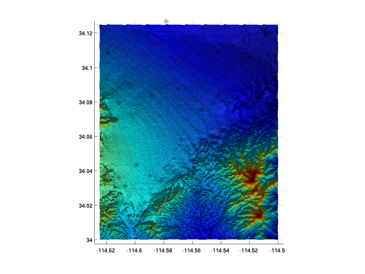
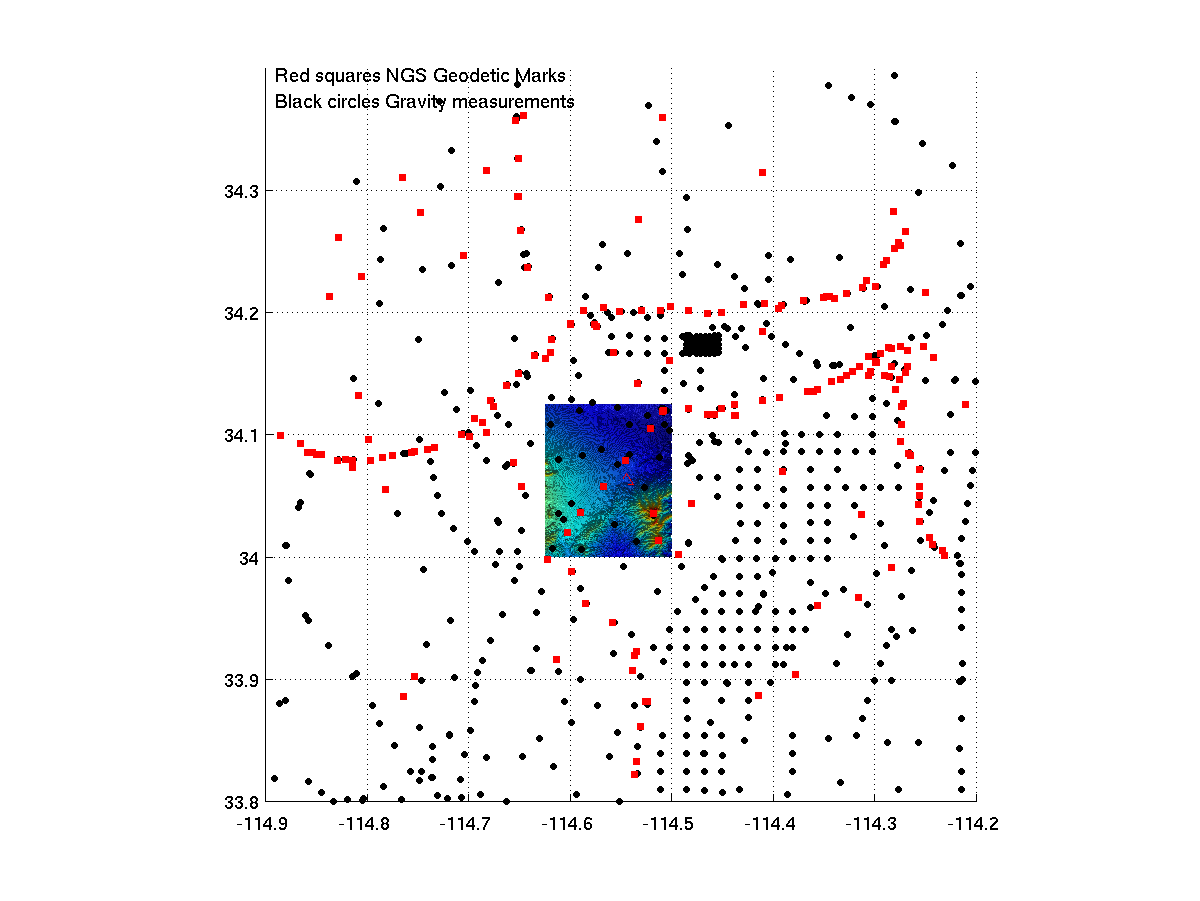
Maps of field area and
existing data. Measurements of
gravity in Building 54. Figure from class: |
|||
|
Lec 5 |
Summary of activities for
paper preparation by Thursday, Jan 27. FC05_Mfiles
folder with 2004 and 2005 data |
|||
|
Lec 6 |
Summary of GPS data files
with final results. Table below
contains links to files. |
Coordinates of Field camp
BASE Station:
2005 Latitude
34.062513490 Long 245.455947957
Ellip. Height 234.5261 (m)
2004 Latitude
34.062574001 Long 245.455946567
Ellip. Height 234.4659 (m)
GPS Results
|
Day |
NEU |
GEOD |
Summary |
|
05 008 |
|||
|
05 009 |
|||
|
05 011 |
|||
|
05 012 |
|||
|
|
|
|
|
|
04 010 |
|||
|
04 011 |
|||
|
04 012 |
|||
|
04 014 |
|||
|
04 015 |
Tidal correction files
|
Tidal correction
(micro-gal) as function of UTC for the field camp location |
|
|
Tidal corrections at MIT |
|
|
Tidal corrections for 2004
field camp. |
Corrections are generated
with program ETGTAB which is available as a Fortran program from
http://www-geod.kugi.kyoto-u.ac.jp/iag-etc/etcdat/etgtab/etgtab.zip
Vidal Regional Gravity file CA_gravity.txt